Accelerate Productivity in 2025
Reignite Growth Despite the Global Slowdown
Industries utilize light detection and ranging (LiDAR) as a remote sensing technology to measure distances using laser pulses. It finds diverse applications across industries, including autonomous vehicles, land mapping, and robotics. Companies are leveraging lidar technology to replace traditional mechanical components with electronic ones, making them more compact and affordable. Additionally, the use of multiple lasers and advanced algorithms allows for higher resolution and improved accuracy.
These innovations drive the development of cost-effective lidar solutions. In this research, you find the top LiDAR applications across 10 industries based on our analysis of 880+ emerging companies. Read more to explore the top lidar use cases and find out how you can use lidar.
Tree Map reveals the Impact of LiDAR Applications across 10 Industries
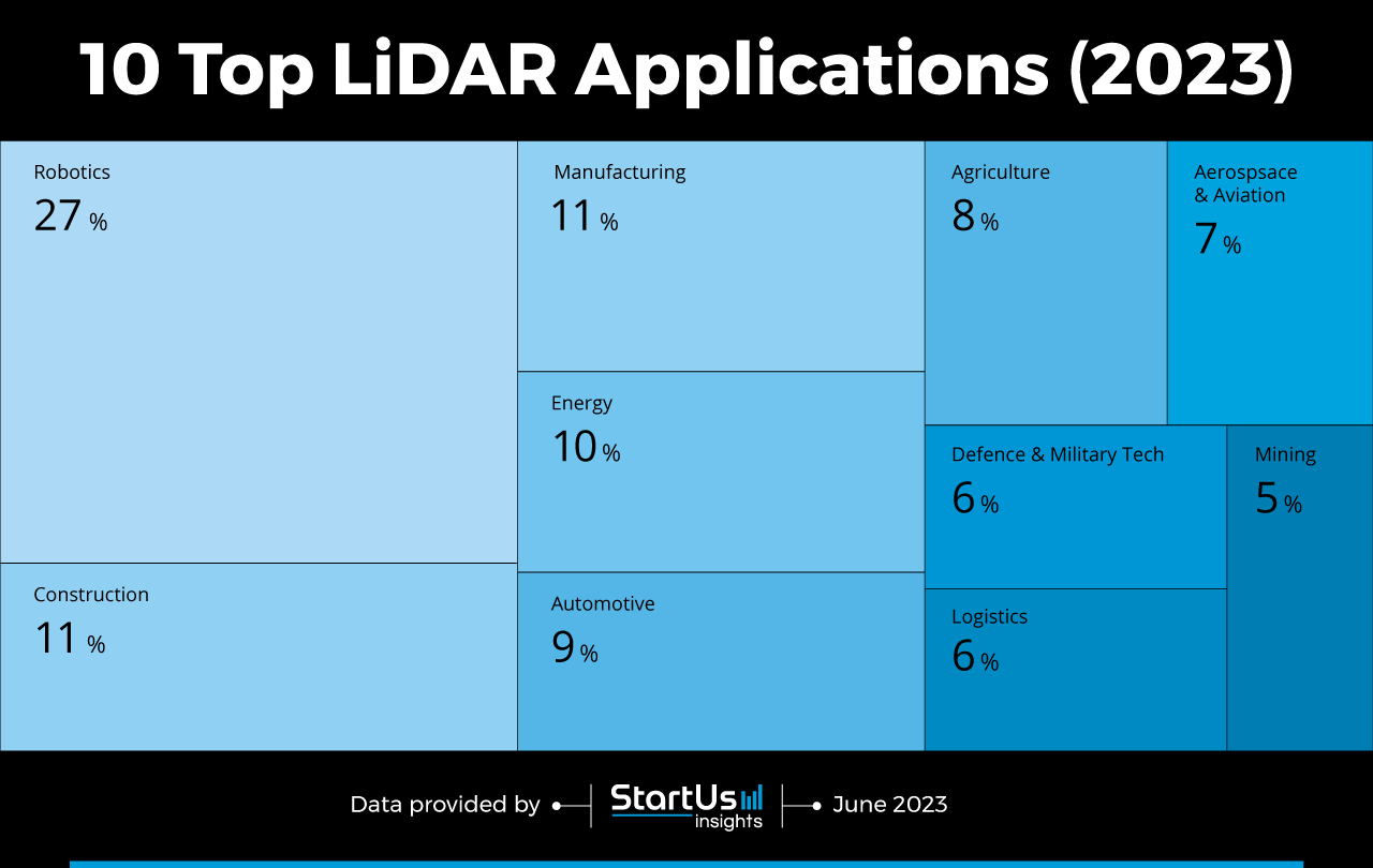
The Tree Map below illustrates the top applications of LiDAR across 10 industries in 2023 and 2024. Within the construction and manufacturing industries, lidar enables accurate and efficient surveying, planning, and quality control. Utilities utilize LiDAR to assist in the design, installation, and maintenance of renewable energy assets such as wind turbines and solar panels.
LiDAR enhances the safety and performance of autonomous and assisted driving systems by providing high-resolution information about road and traffic conditions. For farmers, it enables precision farming and crop management by monitoring soil health, plant growth, and pest infestation.
Additionally, the aviation industry uses LiDAR to improve aircraft, satellites, and space debris detection and tracking. LiDAR systems also contribute to the security and intelligence of military operations by detecting and identifying threats, targets, and terrain features. Lastly, LiDAR optimizes route mapping and underground hazard detection in logistics and mining operations.
Global Startup Heat Map covers 880+ LiDAR Startups & Scaleups
The Global Startup Heat Map below highlights the global distribution of the 882 exemplary startups & scaleups that we analyzed for this research. Created through the StartUs Insights Discovery Platform that covers 3 790 000+ startups & scaleups globally, the Heat Map reveals that the West Coast US has a high concentration of LiDAR startups, followed by the UK and Germany.
Below, you get to meet 10 out of these 882 emerging companies as well as the solutions they develop. These lidar startups are hand-picked based on criteria such as founding year, location, funding raised, & more. Depending on your specific needs, your top picks might look entirely different.
Top LiDAR Applications on 10 Industries (2023 & 2024)
1. Robotics
The intersection of LiDAR and robotics revolutionizes the field of autonomous systems. Robotics companies integrate novel LiDAR sensors in robots to perceive and navigate surroundings with better accuracy. This also allows robots to detect and precisely locate objects, map surroundings in real-time, and navigate complex terrains and obstacles with ease.
Some robotics businesses combine lidar with AI to make intelligent decisions and adapt robot actions based on real-time around obstacles. Moreover, LiDAR and robotics streamlines autonomous vehicle operation, warehouse automation, precision agriculture, search and rescue operations, and more. In challenging environments, it enables robots to protect more lives while operating safely and autonomously in dynamic environments.
Outsight provides LiDAR-based Situation Awareness
Outsight is a French startup that develops LiDAR-based situation awareness software for robots. The startup’s lidar sensor leverages laser beams to measure distances and create 3D maps of the environment. The software then processes the raw data in real time and extracts actionable information. The robot uses this for object detection, tracking, classification, and free space classification.
Outsight’s software is compatible with various manufacturers, enabling easier integration into robotic hardware. This enables autonomous movement for robots, logistics automation, and spatial intelligence. Outsight’s software makes it easier for small-scale robotic companies for easy access and use LiDAR.
2. Construction
LiDAR technology enables accurate and efficient data collection, mapping, and visualization in the construction industry. It facilitates rapid data collection for surveying and mapping by capturing 3D information on construction sites, structures, and vegetation. This streamlines the planning and design phases. Construction companies also utilize LiDAR data to create accurate digital twins of construction sites, facilitating simulation, risk assessment, and decision-making.
Builders integrate LiDAR data with building information modeling (BIM) software to further enhance model accuracy and completeness. Construction professionals combine LiDAR point cloud data with other project information, such as mechanical, electrical, and plumbing (MEP) systems. This allows them to improve coordination, reduce clash detection, and aid clash resolution, leading to smoother construction workflows.
Mach9 aids in Construction Image Capture
US-based startup Mach9 makes a software solution that automates the production of 2D and 3D maps from LiDAR and image data. The company’s software, Mach9 Geospatial Production Platform, uses AI to quickly process LiDAR data and generate 2D or 3D engineering models. It also automates the analysis of key measurements such as distance and clearance. By using Mach9’s software, construction companies reduce the time taken to create maps, improve the accuracy of building plans, and help in decision-making.
3. Manufacturing
The manufacturing industry needs an accurate and efficient perception of the manufacturing environment and processes. LiDAR facilitates this by providing high-precision 3D data for tasks like quality control, robotic guidance, inventory management, and process optimization. By scanning objects or products with LiDAR, floor operators compare the obtained 3D data with the reference models to identify deviations, defects, or dimensional errors. This allows for better quality control and product inspection automation.
LiDAR sensors also provide factory machines with real-time perception of their surroundings. This, in turn, allows them to navigate safely in dynamic manufacturing environments and interact with objects and humans with precision. LiDAR-based guidance systems enhance automation processes by enabling machines to perform pick-and-place operations, assembly, and material handling more efficiently.
SiLC Technologies offers a LiDAR-based Vision System
SiLC Technologies is a US-based startup that creates Eyeonic Vision System, a coherent vision and chip-scale LiDAR system for the manufacturing industry. Its LiDAR system uses frequency-modulated continuous-wave (FMCW) technology to offer long-range, interference-free low-latency object classification and threat detection.
The system utilizes a fully integrated silicon photonics chip, providing more definition and precision than legacy LiDAR systems. This enables its sensor to measure the shape and distance of objects with high precision at long distances. SiLC Technologies’ LiDAR sensors are small, lightweight, and cost-effective, making them ideal for the assembly line.
4. Energy
Within the energy industry, LiDAR provides precise data for optimizing renewable energy resources, assessing sites, and enhancing energy efficiency. Wind energy assessment benefits from remote data collection, optimizing turbine placement, and design. Floating LiDAR systems mounted on buoys or fixed platforms gather information about wind conditions, wave patterns, and seabed topography.
Offshore wind farms also rely on lidar for selecting suitable locations, designing support structures, and estimating energy potential. Further, solar energy assessment companies employ LiDAR to identify optimal installation sites, maximizing energy production. Transmission line monitoring, on the other hand, utilizes lidar on drones or aircraft to detect vegetation encroachments and structural defects.
The application of LiDAR technology thus enables accurate and detailed environmental data acquisition, driving efficiency, reducing costs, and promoting sustainability.
Thrust offers Energy Infrastructure Inspection Drones
Lithuanian startup Thrust develops Green Bee and Target Fox, its multifunctional and customizable drone systems for aerial inspection and data collection. The drones combine lidar and photogrammetric systems to capture high-quality data at scale with minimal operational costs. Utilities use it for aerial inspection of energy lines and enable faster troubleshooting and diagnosis of energy bottlenecks.
Thrust’s drones fly at higher speeds with greater payload weight, making them suitable to carry more equipment. Thrust’s drones provide a more sustainable, efficient, and profitable way for energy companies to conduct infrastructure inspections, replacing helicopters and other expensive methods.
5. Automotive
The automotive industry leverages LiDAR for accurate object detection and tracking in autonomous driving systems. This allows vehicles to improve situational awareness for improved collision avoidance and pedestrian detection. Additionally, car manufacturers use LiDAR for high-definition mapping and precise localization of vehicles. LiDAR sensors create detailed maps of roads, including lane markings, curbs, and other infrastructure.
These maps, combined with real-time lidar data, help autonomous vehicles accurately localize themselves and determine their exact position and orientation. Auto manufacturers also use LiDAR to detect surface defects like potholes and cracks.
Companies are now integrating LiDAR with other sensors such as cameras, radar, and ultrasonic sensors. This approach combines the strengths of each sensor type to provide a comprehensive perception system for autonomous vehicles.
Zvision offers Solid-State LiDAR Sensors for Navigation
Zvision is a Chinese startup that leverages micro-electromechanical system technology (MEMS) to develop solid-state LiDAR sensors. The startup’s sensors employ tiny mirrors to reflect laser light, enabling the creation of high-resolution 3D images. These LiDAR sensors generate a comprehensive 3D map of the environment, ensuring safe navigation for autonomous vehicles.
They detect pedestrians and other vehicles to mitigate accidents. The scanning method also features a higher resolution and longer lifetime as well as withstands extreme conditions such as shock and vibration. Zvision thus facilitates end-to-end LiDAR system design and proprietary hybrid circuit chip development for automotive applications.

6. Agriculture
LiDAR technology revolutionizes agriculture with its crop management applications. Farmers mount LiDAR sensors on drones or ground vehicles to generate 3D maps for crop monitoring and soil management. This enables precision farming by creating digital elevation models of the fields. It allows for accurate soil analysis and variable rate application of inputs based on the specific needs of different areas within a field. LiDAR also helps farmers in identifying and mapping weeds within a field.
By distinguishing between crops and weeds, lidar-integrated robots are able to precisely target weeds and improve control measures, like selective herbicide application. Framers further leverage LiDAR to generate accurate topographic maps, including elevation and slope information. This data allows agri companies to optimize field drainage systems, identify areas prone to waterlogging, and plan irrigation infrastructure.
Airolit makes an Airborne LiDAR System
Swedish startup Airolit manufactures CHCNAV AlphaAir 450, a customized drone sensor system for agricultural applications. It utilizes LiDAR to capture high-resolution 3D data of the terrain and vegetation to create a 3D map. Farmers use this map to measure crop health, identify areas of stress, as well as plan irrigation and fertilization.
The system consists of a drone-mounted sensor for farmers to fly over farms and plantations and collect geospatial information for agricultural surveys. It also integrates a laser scanner with an industrial-grade camera and an inertial navigation system for quality data collection, enabling data-driven agriculture.
7. Aerospace & Aviation
LiDAR technology enhances airport operations by providing precise measurements of runway conditions, including the detection of foreign object debris (FOD) and runway surface damage. It also assists in the planning and design of new airport infrastructure. Aircraft manufacturers integrate LiDAR sensors into collision avoidance systems in aircraft to detect and track objects in the surrounding airspace.
This improves safety by providing pilots with real-time information about potential obstacles or other aircraft in their vicinity. The aerospace and aviation industries further leverage LiDAR scanners to inspect wind turbines in aircraft. These scanners quickly assess the structural integrity of wind turbine blades, detect defects, and monitor their condition over time. Additionally, aircraft manufacturers employ LiDAR for precise navigation and obstacle avoidance, improving safety.
Ommatidia provides a LiDAR-based Metrology Instrument
Ommatidia is a Spanish startup that develops a LiDAR-based metrology instrument for the in-orbit characterization of large deployable reflectors (LDR). The startup’s technology has no moving parts, is lightweight, and offers a high range of accuracy. The startup’s design is specifically for recovering the shape of large reflectors working at short wavelength bands, serving earth observation (EO) or telecommunication purposes.
The instrument also features metrology-grade calibration with compensation for thermal effects. For aerospace companies and space agencies, Ommatidia’s instrument minimizes measurement time and cost compared to photogrammetry or hand scanners.
8. Defence & Military Tech
The defense and military industry utilizes LiDAR to guide missiles and weaponry as well as improve attack detection. The military uses LiDAR-based speed measurement to gather accurate speed data for missiles, simplifying missile performance evaluation and optimization. They also employ LiDAR for counter-mine warfare.
For this, airborne laser mine detection systems (ALMDS) are used. They also enable the detection of underwater and near-surface mines by scanning large areas quickly and producing detailed maps of the seabed. Further, armies utilize LiDAR systems to detect synthetic aerosol clouds containing biological or chemical agents at long range, delivering early warnings of biological attacks.
Other use cases of lidar in the military include 3D perception systems for improved situational awareness and in military drones for autonomous navigation.
Tampa Deep Sea Xplorers develops LiDAR-powered Military Vehicles
US-based startup Tampa Deep Sea Xplorers manufactures autonomous underwater vehicles (AUVs) that use LiDAR and high-resolution cameras for subsea data collection. The startup’s Barracuda AUV is a compact and affordable vehicle that operates at depths up to 4000 meters. This enables defense agencies to perform various military applications such as mine countermeasures, surveillance, and anti-submarine warfare.
It also enables military researchers and product development teams to collect data faster and with more flexibility, thereby shortening launch cycles for military undersea systems. Tampa Deep Sea Xplorers provide deeper, faster, and cheaper AUVs for military agencies to collect more data and with more maneuverability than existing systems.
9. Logistics
Logistics companies mount LiDAR sensors on autonomous trucks, drones, or delivery robots to generate real-time 3D maps. This allows delivery vehicles to detect and avoid obstacles, identify road conditions, and plan efficient routes. By scanning the shelves and storage areas, LiDAR sensors accurately measure the dimensions and volumes of items, improving inventory accuracy and streamlining stock management.
LiDAR also aids logistics companies in sorting and quality control processes by quickly scanning and measuring packages or products. This enables automated systems to identify damaged items, irregularities, or other defects, ensuring high-quality standards and reducing human error.
Unity Drive makes Solid-State LiDAR Sensors for Logistics
Unity Drive is a Chinese startup that provides solid-state lidar sensors for the logistics industry. They enable mobile robots and vehicles to measure the distance and shape of any surface, even in fog or dust. The startup also utilizes AI to analyze the data collected by the sensors and generate 3D maps of the environment.
The startup’s LiDAR sensors help logistics mobile robots such as automated guided vehicles (AGVs) and unmanned forklifts to navigate and avoid obstacles more efficiently and safely. The waterproof nature of the sensors further allows logistics operations to ensure operations in varying climate conditions. Unity Drive’s solid-state LiDAR sensors allow logistics companies to reduce running costs, improve productivity, and enhance robot safety for faster and more accurate deliveries.
10. Mining
The mining industry integrates LiDAR for precise 3D mapping and monitoring. This drives automation capabilities while enhancing safety and efficiency in mining operations. LiDAR finds use for accurate mapping and surveying of mining sites, allowing for the creation of high-resolution 3D models. This helps project managers identify the topography, terrain features, and potential hazards in mining areas, aiding planning and design.
LiDAR also allows them to measure the volume and monitor the changes in stockpiles of extracted minerals and ores. By comparing pre- and post-blast scans, LiDAR helps assess the impact of blasts in surrounding structures, detect damages, and ensure compliance with safety regulations. Mining professionals further utilize LiDAR for mapping underground mines where traditional surveying methods are challenging and time-consuming.
Lastly, lidar enables autonomous mining vehicles to navigate complex mining environments, reducing the risk of accidents.
Emesent facilitates Underground Mine Mapping
Australian startup Emesent offers Hovermap, a mobile scanning unit that combines autonomous drones and LiDAR sensors. It enables mining companies to accurately map underground mines in 3D and autonomously collect data in challenging underground environments.
They deploy Hovermap on any drone vehicle or backpack to obtain high-quality 3D data in stopes, shafts, drifts, and other inaccessible areas. This empowers mining companies to make informed decisions and optimize workflows. Emesent’s mobile scanning unit enables mining companies to improve safety and efficiency at a fraction of the cost.
Discover All LiDAR Applications & Startups
Lidar technology provides the opportunity to efficiently and accurately collect data much quicker than traditional methods. As a result, lidar has the potential to make a significant impact on industries such as navigation, construction, engineering, environmental planning, architecture, and more. With lidar, solutions for blind spot monitoring, lane centering, and automatic parking assistance are becoming more and more accessible for businesses. Get in touch to identify specific lidar companies & solutions that advance your business!


![10 Top Digital Twin Startups and Companies for Industry 4.0 [2025]](https://www.startus-insights.com/wp-content/uploads/2025/06/Digital-Twin-Startups-for-Industry-4.0-SharedImg-StartUs-Insights-noresize-420x236.webp)


