Accelerate Productivity in 2025
Reignite Growth Despite the Global Slowdown
Earth observation companies are improving how we monitor and understand our planet by combining satellite technology with AI and analytics. In this list, we highlight 10 emerging startups pushing the boundaries of geospatial intelligence from automated Earth analysis and flexible antennas to self-service satellite tasking and deforestation tracking. These companies are reshaping industries such as climate risk, agriculture, and defense with their innovati
Global Startup Heat Map highlights Emerging Earth Observation Companies to Watch
Through the Big Data & Artificial Intelligence (AI)-powered StartUs Insights Discovery Platform, covering over 7M+ startups, 20K+ technology trends plus 150M+ patents, news articles & market reports, we identified 90+ earth observation startups.
The Global Startup Heat Map below highlights the 10 earth observation companies you should watch in 2025 as well as the geo-distribution of earth observation startups & scaleups we analyzed for this research.
According to our data, we observe high startup activity in the US and the UK, followed by Germany. The top 5 Startup Hubs for Earth Observation are London, San Francisco, Los Angeles, Paris, and Berlin.

Meet Emerging Earth Observation Companies to Watch (2025)
We hand-picked startups to showcase in this report by filtering for their technology, founding year, location, funding, and other metrics. These 10 earth observation startups work on solutions ranging from low-flying satellites and climate risk reporting tools to high-resolution satellites and flexible satellite antennas.
- Bhusatyam Technologies – Earth Observation Solutions
- askEarth – AI-powered Satellite Image Analysis
- Captis Space Systems – Low-flying Satellites
- Galeio – Automated Earth Analysis
- Map Impact – Climate Risk Reporting Tools
- NordSpace – Space Missions Satellite Systems
- Mithril Technologies – Flexible Satellite Antennas
- Marble Imaging – High-resolution Satellites
- OpenAtlas – Deforestation Advanced Monitoring
- Eartheye Space – Self-service Satellite Tasking
1. Bhusatyam Technologies
- Founding Year: 2022
- Location: Indore, India
- Use For: Earth Observation Solutions
Indian startup Bhusatyam Technologies provides useful insights using AI-driven geospatial analytics alongside satellite and drone footage to deliver earth observation solutions. Eartheye Space employs deep learning methods and computer vision techniques to analyze high-resolution optical, thermal, and synthetic aperture radar (SAR) data.
Additionally, they utilize MLOps tools to streamline the extraction of major patterns and trends from these diverse datasets.
Its geospatial analytics services include real-time monitoring apps, custom geoanalytical models, and the processing of satellite and drone information. Moreover, it creates automated pipelines for the interpretation of data from satellites and drones.
The startup also creates automated pipelines for the interpretation of data from satellites and drones. Further, it combines GPS/GNSS for high-precision georeferencing, InSAR techniques for monitoring ground deformation, and hyperlocal weather forecasting for environmental impact assessments.
2. askEarth
- Founding Year: 2023
- Location: Zurich, Switzerland
- Use For: AI-powered Satellite Image Analysis
Swiss startup askEarth creates an AI-driven geospatial intelligence engine that enables organizations to access satellite image analysis and geographic intelligence. Its Geo-spatial Intelligence Agent (GIA) uses LLMs to interpret and analyze satellite images to extract vital insights from massive geographic datasets in real time.
Additionally, it improves geospatial intelligence by integrating deep learning techniques with advanced natural language processing. This integration facilitates conversational queries, making complex spatial datasets more accessible and user-friendly.
The platform offers an interactive map and chat-based interface for intuitive data exploration. It also integrates with internal APIs and enterprise systems, uncovering hidden patterns within complex datasets.
3. Captis Space Systems
- Founding Year: 2023
- Location: Dresden, Germany
- Use For: Low-flying Satellites
German startup Captis Space Systems creates CubeSats for very low Earth orbit (VLEO) to improve Earth observation capabilities. It uses aerodynamic attitude control systems that make use of control surfaces to reduce atmospheric drag and preserve precise satellite orientation.
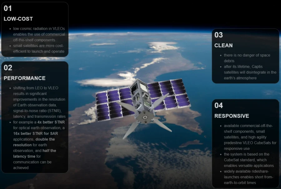
Additionally, this enables the use of commercial off-the-shelf (COTS) components in satellite systems by leveraging the reduced cosmic radiation levels in certain orbital environments. Consequently, it facilitates the development of responsive and cost-effective satellite solutions. Operating in VLEO mitigates space debris problems by ensuring that satellites disintegrate when their missions are over.
It also improves the resolution, signal-to-noise ratio, and latency of Earth observation data. Captis Space Systems offers high-performance, sustainable Earth observation solutions by utilizing the benefits of VLEO operations.
4. Galeio
- Founding Year: 2024
- Location: Paris, France
- Use For: Automated Earth Analysis
French startup Galeio advances automated Earth analysis by creating geospatial foundation models specifically for satellite data. It trains these models in a self-supervised manner on terabytes of uncurated satellite imagery. This allows them to effectively perform tasks like segmentation, classification, and change detection.
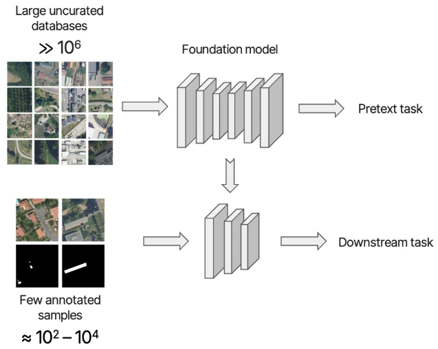
It provides high-resolution optical/IR models with 20 cm image resolution for thorough object detection and land-use mapping. Additionally, its capacity to generate accurate representations of satellite images minimizes the need for large annotated datasets during fine-tuning.
Further, the startup’s technology extracts actionable insight from satellite data with high automation and accuracy.
5. Map Impact
- Founding Year: 2023
- Location: Bristol, UK
- Use For: Climate Risk Reporting tools
UK-based startup Map Impact develops tools for reporting climate risk using satellite earth observation data. These tools provide unbiased analysis of sustainability and environmental performance issues. Moreover, it offers data-driven solutions for biodiversity monitoring, drought assessment, heat stress evaluation, and wildfire risk detection. By integrating remote sensing, geospatial analytics, and modeling, it effectively evaluates natural assets.
It enables businesses, legislators, and environmentalists to monitor ecosystem health and take proactive measures to address climate concerns. Its portfolio of tools includes BiodiversityView, DroughtView, HeatView, and WildfireView. Further, the startup aligns its tools with evolving environmental laws by collaborating with ecologists, regulators, and industry stakeholders.
Want to Explore 90+ Earth Observation Startups & Scaleups?
6. NordSpace
- Founding Year: 2022
- Location: Markham, Canada
- Use For: Space Missions Satellite Systems
- Funding: USD 5 million
Canadian startup NordSpace creates ready-to-use satellites, portable spaceports, and responsive orbital launchers with vertically integrated solutions. It uses 3D-printed liquid rocket engines that run on sustainable fuels to design and build the Tundra launch vehicle. It also carries payloads up to 500 kg into low earth orbit (LEO).
Additionally, the startup’s Spaceport Canada has several launch pads with a variety of inclinations. Its Zephyr green in-space propulsion technology facilitates satellite moves using non-toxic propellants. Its Athena satellite bus offers a uniform platform for a variety of space missions.
Further, NordSpace’s Chronos series of imagers offers RGB, multispectral, and hyperspectral options for Earth observation and situational awareness. The startup aims to simplify travel from any location on Earth to any location in space by offering comprehensive, environmentally friendly space mission solutions.
7. Mithril Technologies
- Founding Year: 2023
- Location: Cambridge, Massachusetts, US
- Use For: Flexible Satellite Antennas
US-based startup Mithril Technologies creates flexible satellite antennas. It uses electrostatic actuation to actively reshape deployable mesh reflector surfaces in orbit. Moreover, this technology allows for real-time control over antenna beam steering, focusing, and gain shaping by altering the geometry of the reflector.
It offers the capacity to create steerable, focusable dishe reflectors. This eliminates the conventional trade-off between surface precision and antenna diameter and allows for larger deployables.
Further, this technology improves applications in satellite communications, defense, and weather monitoring. It offers enhanced atmospheric sensing and scanning capabilities. Mithril Technologies also advances geostationary satellite antenna systems by providing technologies for environmental monitoring and space-based communication.
8. Marble Imaging
- Founding Year: 2023
- Location: Bremen, Germany
- Use For: High-resolution Satellites
German startup Marble Imaging builds a constellation of extremely high-resolution Earth observation satellites to provide daily analysis and insights about our planet. It uses dual-instrument payloads to obtain imaging in eight spectral bands, such as visual (VIS), near infrared (NIR), and short-wave infrared (SWIR).
The ground sampling distance for VIS/NIR is 0.8 meters, while for SWIR it is 6 meters. This setup enables detailed monitoring of infrastructure, maritime operations, and environmental changes. It further offers features such as daily worldwide coverage and advanced AI-powered data processing algorithms. It also allows for a scalable constellation architecture with up to 200 tiny satellites, each weighing about 130 kg.
9. OpenAtlas
- Founding Year: 2023
- Location: Amsterdam, Netherlands
- Use For: Deforestation Advanced Monitoring
Netherlands-based startup OpenAtlas creates deforestation monitoring systems that use AI and satellite data to aid companies in complying with deforestation regulations. It uses its Atlas Deforestation Advanced Monitoring (ADAM) system to identify and monitor changes in land use. This system is a self-supervised machine learning model that examines high-resolution satellite data.

Moreover, the startup offers multiple system versions, including the retired ADAM v1.0, the VANTAGE-X, and the latest ADAM Viridis. These systems offer major improvements in speed, accuracy, visualization, and user experience.
Further, it offers features like accurate land cover classification, the ability to differentiate between legal and illicit deforestation, and smooth API integration for effective data processing. OpenAtlas also converts intricate geographical data into useful insights to enable businesses to preserve sustainable supply chains and safeguard ecosystems.
10. Eartheye Space
- Founding Year: 2022
- Location: Singapore
- Use For: Self-service Satellite Tasking
- Funding: USD 1.5 million
Singapore-based startup Eartheye Space‘s automated, self-service satellite tasking and insights platform enables businesses to access and analyze Earth observation data. It allows businesses to specify their imaging needs, plan captures, and get high-resolution data instantly.

Additionally, the platform incorporates a number of sensor modalities, such as thermal infrared, synthetic aperture radar (SAR), multispectral, and hyperspectral. This ensures coverage in a variety of operational and climatic settings.
It supports applications in environmental monitoring, infrastructure management, and disaster response. It converts raw imagery into actionable information through the use of computer vision and machine learning algorithms.
Further, the platform offers easy satellite access, automatic data collection, and smooth API interaction for business processes. Eartheye Space also improves the usability, affordability, and accessibility of Earth observation data for businesses that require quick, high-caliber geospatial intelligence.
Discover All Emerging Satellite Tech Startups
The Satellite Tech startups showcased in this report are only a small sample of all startups we identified through our data-driven startup scouting approach. Download our free Satellite Tech Innovation Report for a broad overview of the industry or get in touch for quick & exhaustive research on the latest technologies & emerging solutions that will impact your company in 2025!




![Explore the 10 Top AI Solutions for the Space Industry [2025]](https://www.startus-insights.com/wp-content/uploads/2025/04/AI-Solutions-for-Space-Industry-SharedImg-StartUs-Insights-noresize-420x236.webp)
