Accelerate Productivity in 2025
Reignite Growth Despite the Global Slowdown
Staying ahead of the technology curve means strengthening your competitive advantage. That is why we give you data-driven innovation insights into the data industry. This time, you get to discover 5 hand-picked startups developing wide area surveillance solutions.
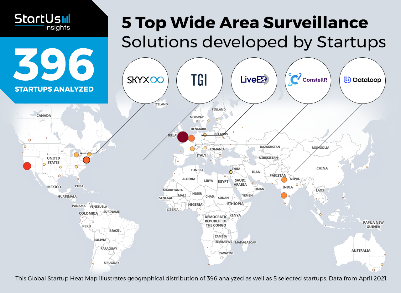
Global Startup Heat Map highlights 5 Top Wide Area Surveillance Solutions out of 396
The insights of this data-driven analysis are derived from the Big Data & Artificial Intelligence-powered StartUs Insights Discovery Platform, covering 1.379.000+ startups & scaleups globally. The platform gives you an exhaustive overview of emerging technologies & relevant startups within a specific field in just a few clicks.
The Global Startup Heat Map below reveals the distribution of the 396 exemplary startups & scaleups we analyzed for this research. Further, it highlights 5 data startups that we hand-picked based on criteria such as founding year, location, funding raised, and more. You get to explore the solutions of these 5 startups & scaleups in this report. For insights on the other 391 wide area surveillance solutions, get in touch.
Dataloop provides an Enterprise-Grade Data Platform
Unmanned aerial vehicles (UAV) and remote sensing systems have numerous use-cases in wide area surveillance for forest conservation and security supervision, to name only two. They carry various imaging devices such as thermal and LiDAR imaging systems to capture detailed earth data. However, the annotation of such complex data requires manual processing, which makes the output prone to human error. Advancements in artificial intelligence and computer vision allow startups to automate annotation processes and, as a result, improve annotation accuracy.
Israeli startup Dataloop provides a data annotation and management platform that integrates sensor fusion and data processing with automatic active learning. The startup offers its Annotation Platform for item classification to pixel-level semantic segmentation, as well as provides data management functionality and custom pipelines for data flow automation. By facilitating data processing and annotation, Dataloop improves the efficiency of land surveying, crop monitoring, traffic surveillance, and industrial inspections.
ConstellR offers Land Surface Temperature Monitoring
With climate change and the increasing pollution rates, monitoring earth conditions such as temperature and weather facilitates environmental hazard assessment. Today, visual and radar imaging techniques enable startups to extract critical information about the environment. For example, infrared imaging provides thermal heat maps of an entire region, which helps monitor hazardous threats such as wildfires, volcanic activity, and gas leaks.
ConstellR is a German startup that provides analytics-ready georeferenced land surface temperature data with high spatial resolution and temperature accuracy. The startup’s CubeSats, miniature satellites, constellation integrates thermal infrared (IR) sensor data into satellite images. With this land surface temperature (LST) information, ConstellR offers a primary dataset for agricultural applications such as vegetation stress measurement, water management, and yield forecast. Additionally, the startup provides disaster and water quality monitoring.
TGI creates the Earth’s Digital Twin
Wide area surveillance is an integral approach for long-range monitoring and data acquisition. The vast amount of data from WAS offers extensive documentation about geography as well as ecological surroundings. This data further enables organizations to make data-driven decisions in precision farming, construction, and national security. Startups utilize multi-sensor systems to capture real-time data and generate spatial intelligence, improving current data acquisition techniques.
US-based startup TGI is building a satellite constellation to map physical activities, processes, and objects on earth in real-time. The TGI Satellite Network (TSN) operates in Total Capture mode using visible and non-visible spectrum imaging. The TSN also integrates a Space-Backhaul-System (SBS) and secure machine-to-machine (M2M) and Internet of Things (IoT) communication network for a seamless data transfer with data centers. TGI’s solutions reduce the dependence on terrestrial sensors and network extensions for WAS, improving surveillance efficiency.
LiveEO uses Satellite Data for Infrastructure Management
Real-time monitoring of vast grids or oil and gas pipelines means high operational expenses and management complexity. Therefore, startups build remote sensing solutions for businesses to accurately monitor their infrastructure at a low cost. For example, wide area surveillance using satellites provides detailed information on land deformation and monitors countrywide infrastructures without needing multiple hardware installations.
German startup LiveEO applies machine learning algorithms to satellite imagery to provide infrastructure monitoring for railways, electricity grids, and pipelines. The startup offers vegetation management, ground deformation, and third-party detection, reducing manual inspection at operation sites. Additionally, LiveEO develops web and mobile applications that provide operation managers with insights on infrastructure health. This allows for planning and task delegation, thereby improving the efficiency of asset monitoring processes.
SkyX Systems builds Aerial Systems for Long-Range Surveillance
Wide area surveillance uses either satellites or aerial vehicles to collect data. Such data acquisition applications demand devices with a high operating range and reliability. That is why startups develop unmanned aerial vehicles with high resilience and performance range. Also, these UAVs support a wide range of imaging devices such as IR and LiDAR sensors, improving data collection capabilities.
SkyX Systems is a Canadian startup that develops wide area surveillance solutions for pipeline integrity management. The startup develops a multi-sensor drone with an operational range of 100 km and 120 kph optimal speed. It also features radio and satellite communication for data transfer. The startup’s drones accumulate visual data, and the proprietary SkyX AI system analyzes it for anomaly classification. SkyX’s solutions allow pipeline operators to track hydrocarbon leaks, as well as monitor corrosion and external disruptions.
Discover more Data Startups
Data startups such as the examples highlighted in this report focus on data ownership, ethical data collection, personal data management as well as security. While all of these technologies play a major role in advancing the data industry, they only represent the tip of the iceberg. To explore more technologies, simply get in touch to let us look into your areas of interest. For a more general overview, you can download our free Industry Innovation Reports to save your time and improve strategic decision-making.