Accelerate Productivity in 2025
Reignite Growth Despite the Global Slowdown
Our Innovation Analysts recently looked into emerging technologies and companies working on solutions for shipbuilding. As there is a large number of companies working on a wide variety of solutions, we want to share our insights with you. This time, we are taking a look at 4 promising Autonomous Survey solutions.
Heat Map: 4 Top Autonomous Survey Solutions
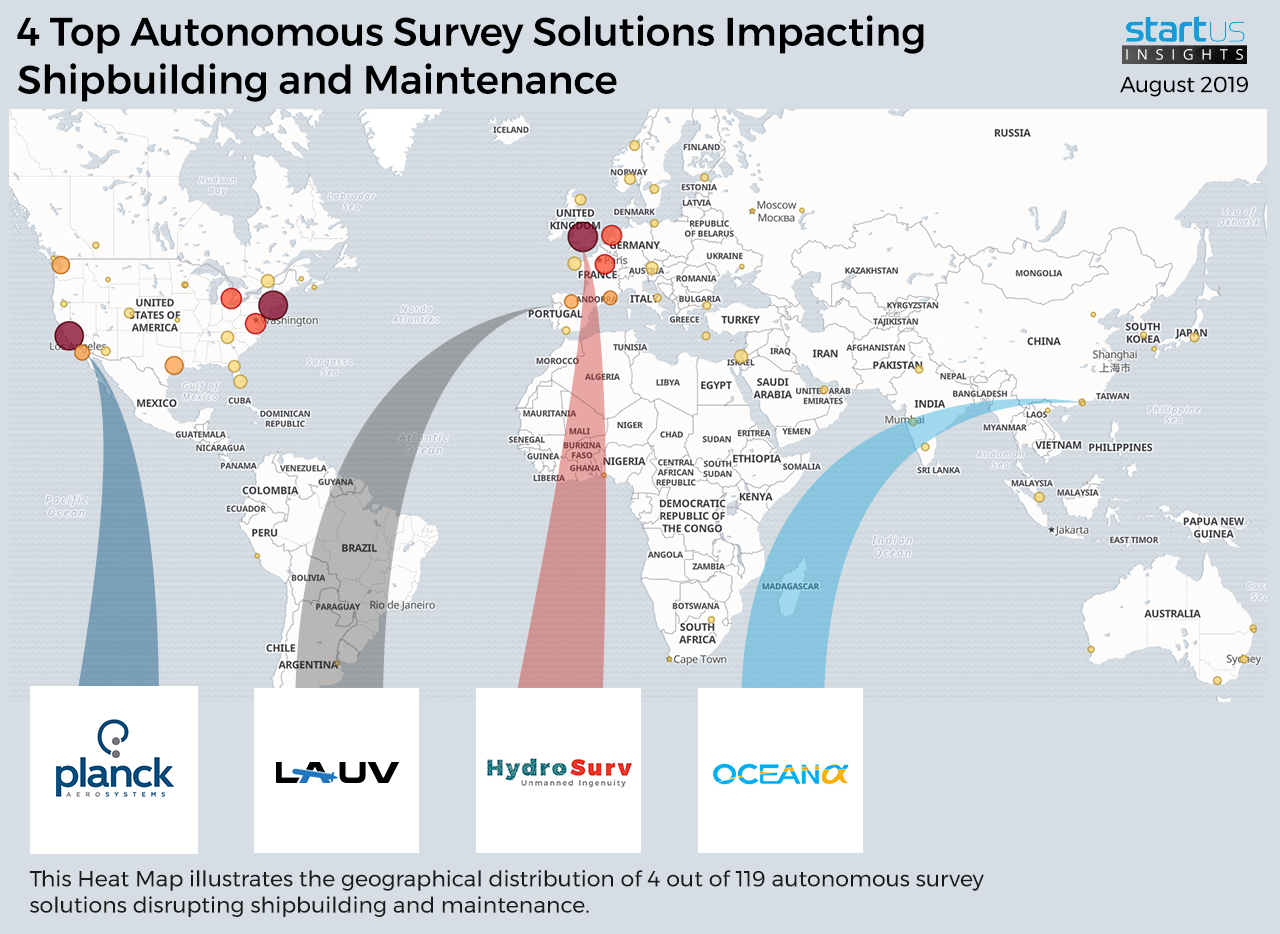
For our 4 top picks, we used a data-driven scouting approach to identify the most relevant solutions globally. The Global Heat Map below highlights 4 interesting examples out of 119 relevant solutions. Depending on your specific needs, your top picks might look entirely different.
Planck Aerosystems – Drones
The shipbuilding industry is steadily adopting drones to conduct continuous quality inspections, test a ship’s emissions, and make deliveries to vessels cruising near the shorelines.
The USA-based company Planck Aerosystems develops autonomous drones for shipbuilding and shipping vessels. Their drones use Artificial Intelligence (AI) and complex computer vision to service ships with minimal external interaction. By facilitating drone landing and take-off in unstable conditions, Planck has solved a vital industry problem as standard drones cannot operate under extreme conditions. The drones are used for aerial surveillance and for identifying and monitoring risks. In addition, they can activate decontamination operations during oil spills and other emergencies.
Ocean Scan-MST – Autonomous Underwater Vehicles (AUVs)
Autonomous Underwater Vehicles have a massive potential in, among other things, exploring the oceans, accompanying ships, providing underwater surveillance, and assessing environmental conditions.
Portuguese company Ocean Scan-MST produces LAUV – Light Autonomous Underwater Vehicles for maritime surveillance and research missions. Designed to be simple to deploy, operate, and recover by a single person, their open architecture allows users to easily integrate new instruments, actuators, algorithms, and behaviors. The LAUV’s operation is supported by Neptus, the command, and control software tailored for the operation of one or more vehicles, covering all the stages of a mission life cycle: configuration, planning, simulation, execution, and post-mission data analysis.
HydroSurv Unmanned Survey – Environmental Assessment Vessels
USVs are ideal candidates for weather data collection and oceanography due to their low cost of deployment, compared to weather ships or research vessels. Modern USVs also embed autonomous systems to automate marine data acquisition while others rely on remote operations. In both cases, they speed up survey time and mitigate the need for humans in the ocean.
UK-based startup HydroSurv Unmanned Survey develops environment assessment vessels. The startup’s electric and hybrid uncrewed surface vehicles are tailored for specific use cases such as inland or nearshore deployment. Besides, its robotics-as-a-service business model allows the startup’s clients to collect marine data on-demand and decrease project costs.
OceanAlpha Group – Unmanned Surface Vessels (USV)
Unmanned Surface Vessels are a cluster of automated vessels that are operated remotely by a computer to facilitate various sea and ocean research missions, patrol dangerous areas, and conduct complex water sampling.
Hong Kong-based OceanAlpha Group design and produce a wide variety of USVs for various purposes, including hydrographic surveys and hydrology research, scientific explorations, search and rescue missions, and fire control. It integrates a single-beam or multi-beam echo sounder, Global Navigation Satellite Systems (GNSS) or Real-TimeKinematic (RTK), a camera, and an obstacle avoidance system to efficiently conduct its tasks. Their wide bandwidth radio station allows the operator to see the results of bathymetric, underwater depth, data in real-time with greater precision.
What About The Other 115 Solutions?
While we believe data is key to creating insights it can be easy to be overwhelmed by it. Our ambition is to create a comprehensive overview and provide actionable innovation intelligence for your Proof of Concept (PoC), partnership, or investment targets. The 4 solutions showcased above are promising examples out of 119 we analyzed for this article. To identify the most relevant solutions based on your specific criteria and collaboration strategy, get in touch.
