Staying ahead of the technology curve means strengthening your competitive advantage. That is why we give you data-driven innovation insights into SpaceTech. This time, you get to discover 5 hand-picked data startups in SpaceTech.
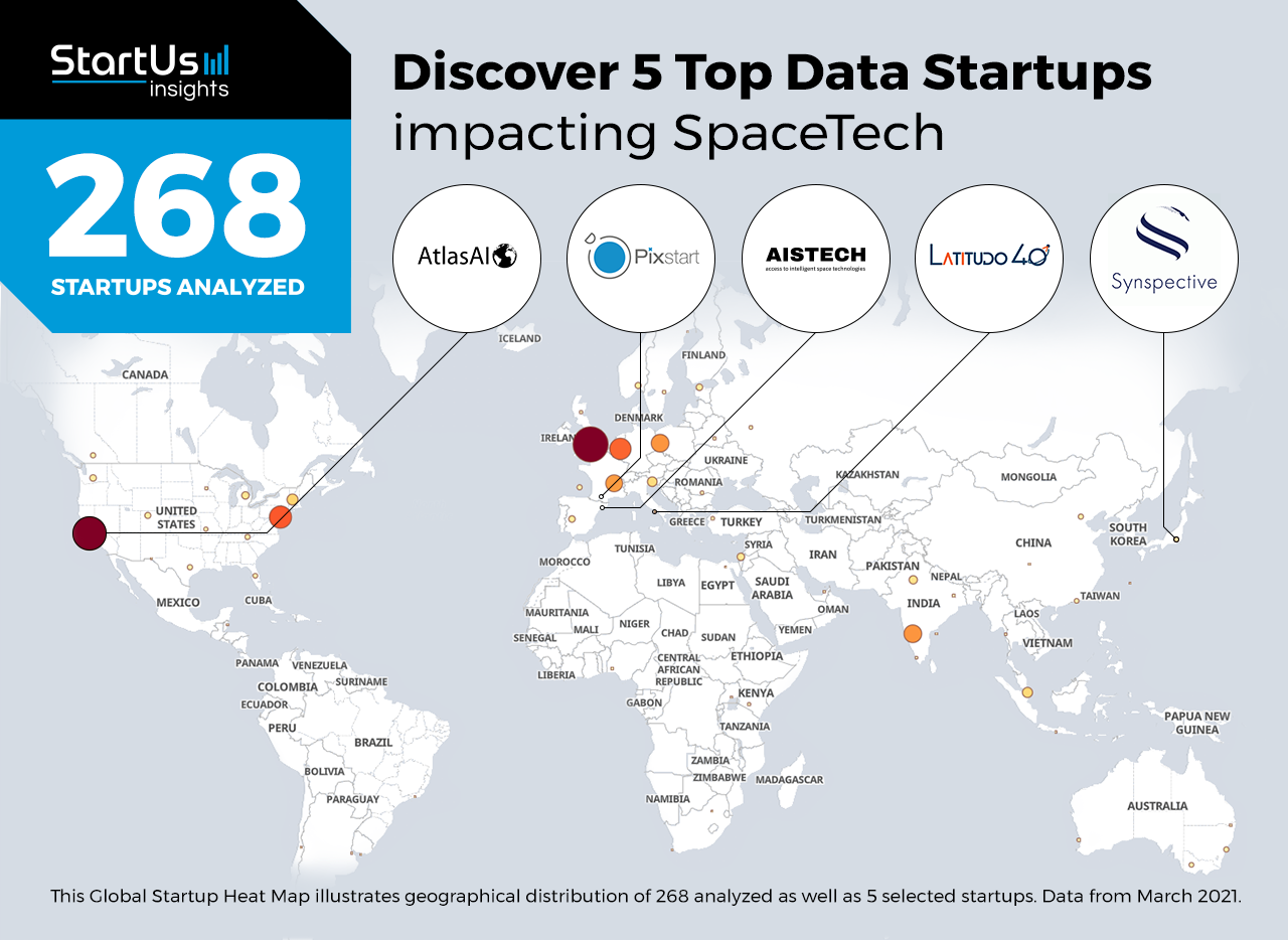
Global Startup Heat Map highlights 5 Top Data Startups in SpaceTech out of 268
The insights of this data-driven analysis are derived from the Big Data & Artificial Intelligence-powered StartUs Insights Discovery Platform, covering 1.379.000+ startups & scaleups globally. The platform gives you an exhaustive overview of emerging technologies & relevant startups within a specific field in just a few clicks.
The Global Startup Heat Map below reveals the distribution of the 268 exemplary startups & scaleups we analyzed for this research. Further, it highlights 5 data startups in SpaceTech that we hand-picked based on criteria such as founding year, location, funding raised, and more. You get to explore the solutions of these 5 startups & scaleups in this report. For insights on the other 263 data startups in SpaceTech solutions, get in touch.
Latitudo 40 develops a Space Data Platform
Commercial SpaceTech has mushroomed in recent years, putting hundreds of satellites in orbit. These satellites gather large amounts of geospatial data. Startups and companies across industries are tapping into this data to derive valuable insights. To this end, startups offer big data & analytics platforms that collect and process satellite images.
Italian startup Latitudo 40 develops EarthAlytics, a data platform for space activities. It utilizes artificial vision to transform satellite imagery into spatial geo-analysis applications. The platform automates the entire workflow from data selection and processing to visualizing it with dashboards. It further taps into ready-to-use connections to search millions of satellite images from leading suppliers. The EarthAlytics Bricks library serves applications in smart grids, transportation, and agriculture, to name a few sectors.
Pixstart provides a Forestry Management Tool
Smart forestry management is critical to ensure the supply of forestry-based products while conserving biodiversity. Ground-based data collection is expensive and requires intensive manual labor. Earth observation data from satellites, on the other hand, improve forestry management by monitoring large areas in real-time. Moreover, space-based solutions generate accurate forest maps and enable building decision-support tools.
French startup Pixstart leverages space data to enable geo-strategic decisions. Woodwatch, one of the startup’s solutions, enables forestry management and gives suggestions to forest operators. It uses satellite observation data to track forest changes, monitor reforestation, and determine local species, as well as estimate tree heights and quantity of wood. Further, it assists operators in looking for ideal forest plots to harvest, thereby saving time and increasing productivity.
Atlas AI offers Economic Development Intelligence
To expand and tap into new consumers, companies need to rapidly identify new markets. Currently, on-ground data collection is time-consuming and also expensive. Space data presents a new window into economic development by monitoring markers of development from space. Startups offer development intelligence solutions that collect granular details and predict future outcomes.
Atlas AI is a US-based startup offering economic development intelligence from space data. Aperture, the startup’s platform, leverages proprietary data on population, economy, and infrastructure to provide a comprehensive picture of the African continent. It derives village-level insights to identify markets of interest, as well as locations for infrastructure projects. Moreover, it monitors the footprint of various programs and assists managers in resource-allocation decisions.
Aistech Space provides Hydrology Monitoring solutions
Natural water resources are under threat from pollution, urban growth, and deforestation. Hydrology monitoring solutions help reverse the impact of these activities, as well as ensure the sustainable use and distribution of water. For a comprehensive picture, such solutions need to place local data in the context of global and historical trends. This is why space data startups leverage satellite information for hydrology monitoring.
Spanish startup Aistech Space provides hydrology monitoring solutions in which it uses space data to offer a global view of water resources. It complements satellite images with ground observations to determine the spatiotemporal dynamics of surface water. The startup also offers space data-based predictive models for water quality assessment and fishing intelligence.
Synspective works on Geospatial Data & Analytics
Remote sensing monitors various physical characteristics, important for mapping forest fires, weather patterns, urban changes, and the seafloor. One solution to capture the details accurately is synthetic-aperture radar (SAR), which creates 2D or 3D maps of landscapes. SpaceTech startups use SAR satellites to collect geospatial data. Moreover, the analysis of this data provides deep insights into various phenomena and how they impact human activities, and vice versa.
Synspective is a Japanese startup providing geospatial data using SAR satellites. The startup’s StriX satellite collects data round-the-clock, irrespective of the weather conditions. It offers solutions for land displacement monitoring and flood damage assessment. For urban environments, it enables facility monitoring and solar-potential mapping. The startup also offers subscription-based and tailored services that match the needs of their client’s business and industry.
Discover more SpaceTech startups
The 268 data startups in SpaceTech, such as the 5 examples highlighted in this report, focus on space-based Earth monitoring and geospatial analytics as well as forestry management. While all of these technologies play a major role in advancing space activity, they only represent the tip of the iceberg. To explore more space technologies, simply get in touch to let us look into your areas of interest. For a more general overview, you can download our free Industry Innovation Reports to save your time and improve strategic decision-making.


